The Story of West Adams Heights
Let's start in the 1860s. As you may dimly remember from your high school U.S. history class, the U.S. Congress exploited the absence of their Southern colleagues during the Civil War (aka the War Between the States or even the War of Northern Aggression, depending on your orientation and/or ideology) to push through a whole slate of land legislation designed to hasten western settlement. Chief among these laws was the 1863 Homestead Act which offered a free "1/4 section" (160 acres) to "pioneers" willing to farm and otherwise "improve" the land over a period of 5 years.
Summarily, the West Adams Heights tract (or "Adams Street Homestead Tract No. 2", as it was first known) was homesteaded in 1868 by one Mary Hall. Mary's brother, Charles Victor Hall, was a student who had worked on survey efforts in the area. Charles was a claim-layer as well, opportunistically snapping up a 1/4 section (160 acres) to the south. (I'll detail the C.V. Hall tract in another post.)
Located smack in the middle of the public lands nestled between the pueblo lands surrounding the Plaza and owned by the City of L.A. (which sold off its holdings after statehood in 1850) and the Avila family's Rancho Las Cienegas, Mary Hall's land had most recently been used for cattle grazing. The city though was slowly developing an appetite for residential land (population doubled after 1890, reaching 100,000 in 1900); and, by 1893, school-teacher Hall (now married to military veteran and surveyor William Moore), subdivided her land for "exclusive home sites."
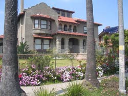
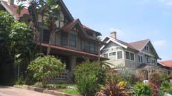
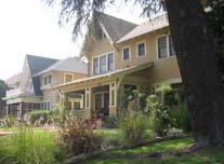
An economic depression rivalling The Big One of the 1930s seized the nation in 1893 perhaps hampering development in West Adams Heights for its first few years as a residential enclave. But recovery arrived in Southern California Country (to borrow a Carey McWilliams phrase) and gigantic houses for rich and socially prominent folks started springing up in West Adams Heights by the turn of the century.
Geographically speaking, West Adams Heights commands a particularly nice spot, on the northern end of a flat mesa that dips south offering views across an undulating plain to the hills now named for Lucky Baldwin. Land baron and Malibu developer Fredrick Rindge built his own "town" house in the tract, just below the crest of the ridge, in 1905. (Sadly, he didn't live to spend much time there, shuffling off this mortal coil in 1906. The house itself, however, still stands and is listed on the National Register of Historic Places.) Hall and Moore built their own house in the southwest corner of the tract (it was plowed under to provide surface parking for the 1948 Golden State Mutual Life Insurance building--an architectural treasure in its own right albeit it of a different stripe--at the corner of Western and Adams).
Between its attractive topography and its architectural riches, it's not hard to see how the area acquired the nickname 'Sugar Hill' in the late 1940s and 1950s when the neighborhood housed numbers of prominent African Americans. (The aforementioned Golden State Mutual Life building is something of a symbol of the economic stature and prominence of Sugar Hill's mid-century denizens; it remains the country's largest African American insurance company.) But before Sugar Hill could be born, those same pioneering African Americans had a battle to win. Like many Los Angeles tracts, land deeds in the West Adams Heights tract came equipped with a slate of restrictions designed to ensure and perpetuate the "desireability" of the area. The most noxious of these restrictions were racial in nature. By the 1940s, the deed restrictions approached expiration. While some absentee landowners welcomed the opportunity to profiteer from an expanded market, others feared the prospect of living in a racially integrated neighborhood and lobbied for the convenants' extension. Eventually, several would-be property owners challenged the constitutionality of the racially-based deed restrictions. These cases were ultimately consolidated and heard at the U.S. Supreme Court. Its 1948 Shelley v. Kraemer decision parses the issue somewhat: declaring not so much that the restrictions themselves violate constitutional provisions but, rather, prohibiting courts from enforcing them. Regardless, in the absence of enforceability, the racially restrictive covenants were rendered impotent.
This triumph of equity, however, was short lived. In 1955, the U.S. government saw fit to target the neighborhood in its bid to connect downtown and the Westside with a freeway. Constructed between 1961-66, Interstate 10 (known locally as the Santa Monica freeway) now plows right through the heart of the West Adams Heights tract.
The freeway succeeded in fragmenting the neighborhood: the 2 halves are not even connected by an overpass. In the aftermath, the trend of absentee landholding continued with some owners concerned more with profits than neighborhood cohesion. Moreover, the area was "up-zoned," effectively incentivizing the demolition of historic single family residences.
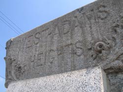
Undeterred by the consequences of these setbacks, residents have remained committed to preserving their quality of life and preserving an unique collection of early 20th century housing styles. The northern part of the neighborhood boasts a particularly effective neighborhood association which meets regularly, actively engaging residents and cementing neighborly links among its ethnically diverse denizens. One of its most commendable beautification projects has been the restoration of the street markers that punctuate the corners of Washington & Oxford, Hobart, and Harvard. (Highway sound walls are apparently in the pipeline as well.)
Like all great cities, L.A. is an ever evolving story and West Adams Heights amply illustrates that. I strongly recommend a visit to this unique, beautiful and historically significant corner of Los Angeles. Heck, you've whizzed past it, and the Armenian Gethsemane Church with it's dome-topped tower, at least 1,000 times on the Santa Monica freeway. Why not get off and check it out? You might just discover your new home.
(West Adams Heights tract boundaries: Western to Normandie, Washington to Adams. West Adams Heights neighborhood boundaries: Western to Normandie, Washington to the 10 freeway.)
Labels: West Adams Places
posted by Adam at 10:25 PM | Permalink
![]()
![]()

<< Home